Landowners put 183 sites to Maidstone council by 23 August. We read all 184 published records: 153 name housing, and the largest is 100 hectares at Leeds.
Landowners and developers put 183 sites to Maidstone Borough Council for its new Local Plan, and every one of them can be looked at online.
The council confirmed the total in a statement published on 7 September. It says the 183 submissions came from 107 respondents during a 10-week window that ran from 15 June to 11.59pm on 23 August.
What the statement does not do is say what was submitted or where. The council’s consultation portal does. Maidstone Live read all of it.
What is actually published
The Call for Sites 2026 page on maidstone.oc2.uk carries a public list of submissions. On 9 September it held 184 records, one more than the 183 the council’s statement gives. The council has not explained the difference and we have not been able to reconcile it.
Each record shows four things: the site name as the submitter typed it, a net developable area, the uses it has been put forward for, and the boundary drawn on a map. Names of the people and companies behind the submissions are not shown on those pages.
Housing dominates, by a long way
We counted every record. A site can be put forward for more than one use, so the numbers below add up to more than 184.
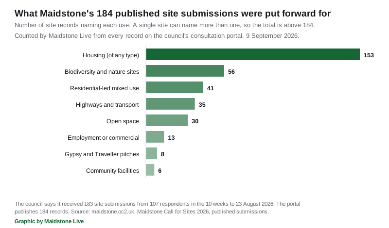
- 153 records name housing of any type
- 56 name biodiversity and nature sites, including biodiversity net gain, woodland and wildlife corridors
- 41 name a residential-led mix of uses
- 35 name highways and transport, such as footpaths, cycle routes or bus stops
- 30 name open space, including allotments and Local Green Space
- 13 name employment or commercial land
- 8 name Gypsy and Traveller pitches or Travelling Showpeople plots
- 6 name community facilities such as schools or healthcare
Three records name utilities, two renewable energy, two retail or town centre uses and two community halls or sports facilities.
The pattern is worth reading carefully. The green-sounding categories are not separate green schemes. They mostly sit on the same records as the housing, because a modern housing submission is expected to offer biodiversity net gain, open space and walking routes alongside the homes.
How big the sites are, where anyone said
Only 94 of the 184 records give a figure for net developable area. The other 90 are published as “No number given”.
Of the 94 that do:
- they come to about 770 hectares between them
- the middle figure is 3 hectares
- 61 are between 1 and 5 hectares
- 9 are 25 hectares or larger
Every figure given is a whole number, and none is below 1, so treat them as rounded rather than surveyed. The council’s own guidance measures sites in hectares and sets a floor of 0.25 hectares, or five dwellings, for housing and commercial submissions.
The largest, as named on the portal:
| Net developable area | Site name as submitted |
|---|---|
| 100 ha | Land East of Upper Street, Leeds |
| 66 ha | (no site name given) |
| 60 ha | Land to the south of Ashford Road, Bearsted, ME14 4NB |
| 50 ha | Wetlands |
| 46 ha | Invicta Park Barracks |
| 34 ha | Field on eastern side of Bull Lane, north of the junction with Bull Lane |
| 32 ha | ‘The barn’ |
| 26 ha | Gore Court House Estate, Otham |
| 25 ha | Clock House Farm, Coxheath, ME17 4PB |
Leeds here is the Kent village east of Maidstone, near Leeds Castle, not the city.
Five records give no site name at all, and several of the names above are too vague to locate without opening the map. That is a real limit on how much the public list tells you.
Invicta Park Barracks is not a new proposal. The site is already a strategic development location in the council’s planning framework, and the council’s own Local Plan pages say it will “look to deliver 1,300 new homes” with an all-through school by 2037, with a supplementary planning document in preparation. Anyone who had submitted a site before was told to submit it again, so allocated land appears in this list alongside untested land.
The number driving all of this
The reason 183 sites arrived is set out in the council’s own guidance pack, published in June.
Councils must use the government’s standard method to calculate minimum housing need. On that method, the pack says, the current minimum working figure is about 1,400 new homes a year in the borough, which “over a minimum 15-year plan period, this equates to 21,000 homes”.
The adopted Local Plan Review requires 1,157 a year. The pack notes that because that plan uses a stepped trajectory, 1,400 is close to what it already demands in its final five years.
The pack also says the new plan is likely to be looking at land for offices, industry, storage and distribution, and it explicitly raises laboratories, gigafactories, data centres, freight and logistics.
What happens next, and what does not
Councillor Tony Harwood, cabinet member for planning and infrastructure, anticipated the reaction. “We recognise that maps showing submitted sites may generate discussion and concern,” he said. “However, these are sites put forward for technical assessment, not approved developments.”
That is accurate. Submitting a site is not a planning application, and the council says no decisions on allocations are made through this exercise.
What follows is a Strategic Land Availability Assessment. Council planners assess each site for suitability, availability and achievability, drawing on transport, ecology, flooding, drainage, minerals, waste and education specialists. Water availability and wastewater capacity are part of that work. Sites that survive get a closer look. Only then does a draft plan go out to public consultation.
The council also says the evidence matters because of local government reorganisation, so that decisions can be taken “whether by the current authority or its successor”.
What it means for you
- You can look at the sites yourself. The published submissions, with boundaries drawn on a map, are at maidstone.oc2.uk/document/forms/689. There are 184 of them, listed 30 to a page.
- A site near you appearing on that map means nothing has been decided. It means a landowner has offered it for assessment.
- This is not your chance to object. There is no public comment stage on the Call for Sites itself. The consultation comes later, on a draft plan.
- If you own land and missed the window, note a discrepancy: the council says the submission period has closed, while the portal still shows a submit button and gives an estimated end date of 23 August 2027, and describes the 10 weeks as how long the exercise would “initially” run. The council’s contact for this is LDF@maidstone.gov.uk.
We will report the Strategic Land Availability Assessment when it is published, and the first draft of the new Local Plan when a consultation date is set.
For planning in the borough day to day, see our Maidstone planning applications page and our planning news. House prices across the borough are tracked on our Maidstone house prices page.
Have your say